|
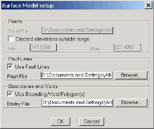
Create a TIN (triangulated irregular network) of a set of points. Any
point file in the xyz format can be used to create a surface model.
Fault lines may be added to the model to control the triangulation
process. Boundaries and voids may also be used to control the appearance
of the model. |
|
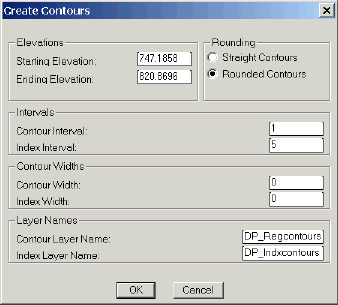
Contours may be created at user defined intervals and placed on user
defined layers. |
|
 |
|
 |
|
 |
|
A mesh may be created of the surface. |
|
Volume calculations may be made between two surfaces. |
|
Create an unlimited number of surfaces. |
|
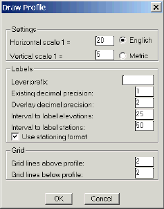
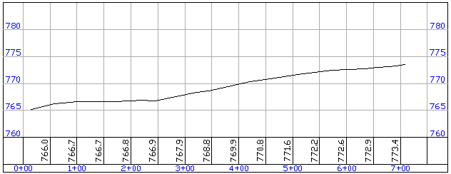
Profiles - select a polyline alignment and cut a profile from the
surface. The profile may then be imported into a drawing. The program
places a grid around the profile and annotates stations and existing
ground elevations on a user defined interval. |
|
 |
|
 |
|
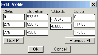
Define proposed profile. |
|
A dialog box will appear alowing you to enter PI stations and elevations
and vertical curves for your proposed alignment. The grades are
calculated and shown in the dialog box for your information. You may
enter a station and grade and change the following elevation. |
|
 |
|
CADian |
CADD 2008 |
CADian MECH
CADian Architectural |
CADian ARCH |
CADian electcad
CADian/Mech-Q Piping |
CADian/Mech-Q HVAC Ducting
|
CADian/Mech-Q Structural
CADian/Mech-Q BOM Prol |
Survey/Cogo |
CADian Road
Digital Terrain Modeling
|
CADian Viewer |
